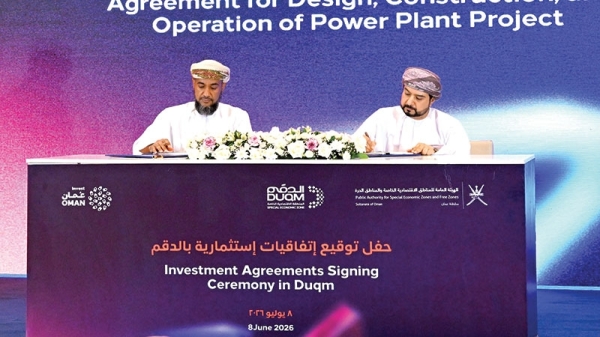
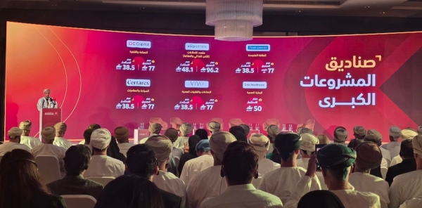
Governorate
of
Dhofar
The Governorate of Dhofar is located in the
south of the Sultanate. The coastal strip stretches for 560km, and the region has an area
of around 1,500km2, of which only 130km2 are affected by the monsoon
rains. The coast of Dhofar is a haven for the fishing industries and sardines are one of
the most prolific fish in the catch as well as lobsters, abalone and prawns. Agriculture
is a main industry in Dhofar and crops such as coconuts, bananas, sweet potatoes (yams),
lemons, papaya, wheat and corn are grown. Traditional crafts include blacksmithing,
goldsmithing, embroidery and needlework.
Dhofar is an area rich in history. In 1992,
an American satellite discovered the remains of a city submerged beneath the sands of the
Omani section of the Rub' al Khali (the Empty Quarter). Initial speculation indicated that
this was the legendary city, Iram Dhat al Emad, distinguished by its imposing columns and
high walls, which is mentioned in the Quran. The site has been subject to much exploration
and study by archaeologists who have dated pottery and glass vessels excavated from the
area at around 100BC. It has also been ascertained that the city sank under the sands due
to what has been deemed a 'light earthquake'. This could be the 'clamour' which is
referred to in the Quran: '..a great clamour was heard in the sky and Shaddad and all who
accompanied him were struck down' - and the city sank below the ground.
The Dhofar region is subdivided
into 10 wilayats. Its climate is dramatically different
to the rest of Oman due to the effects of the
monsoon rains (khareef)
which arrive during the summer months, creating
humidity and moderate temperatures of around 300C.
As a consequence, the area becomes lush and green,
with waterfalls and rivers feeding the surrounding
pastures. The mountain ridge, which receives the
most rain, stretches for 400km from east to west.
During the khareef, springs gush forth and provide
plentiful water supplies for much of the rest
of the year. The fresh greenery is ideal for cattle
grazing and livestock rearing is an important
occupation in the area.
The wilayat of Salalah, which is the
administrative capital of Dhofar, lies on the Arabian Sea, around 1040km from Muscat in
the north. The city has been subject to many historical and archaeological studies over
the years and evidence has been found in the form of writing, inscriptions and signs
indicating that a number of different civilizations have succeeded each other here.
The Manjawi civilization
dwelt in the district of Belid between the 12th
and 16th centuries. At this time, the
area was renowned for its thriving import and
export activities, the main exports being Arabian
horses and frankincense.
It is thought that Ahmed bin Mohammed al Haboudhi
rebuilt the city and renamed it Al Mansourah (The
Victorious) and this status was reaffirmed in
the writings of explorers Marco Polo and Ibn Batuta.
There are three archaeological sites in Al Mughsil
with traces of ancient walls, tombs and mosques.
Not all the sights in Salalah belong to the
past, however. This wilayat contains stunning beaches and steep, mountainous landscapes.
The rocky outcrops on the beach in Mughsil contain many blowholes which burst dramatically
during high tide. Salalah is developing as a tourist resort and is attracting a number of
international hotel chains such as Holiday Inn and Hilton.
Port Salalah, completed in 1998, is
destined to become one of the world's most important container terminals. Its construction
has provided jobs for many Omanis.
The wilayat of Thumrayt is located at the
juncture of all the principal roads linking Dhofar to the rest of the Sultanate. In the
past, it has been a forwarding post on the overland caravan routes to the ports on the
Arabian Sea. It is believed that the lost city of Ubar is in Shisr in Thumrayt. Ubar was
the mythical city mentioned in the 'Tales of the Arabian Nights'. Much of Dhofar's
frankincense was grown in this area and the ancient people would warn outsiders of dangers
such as 'flying snakes' in order to keep them away and thus protect their livelihood. In
Mashid, there are many fresh water springs, which are noted for their depth and which
meander through beautiful scenery. Traditional caravan routes are still maintained in
Thumrayt and the local inhabitants harvest the frankincense each April. Crafts include
spinning and weaving wool, tent-making and palm-frond weaving.
Wilayat Taqah falls between Salalah and
Marbat on the Dhofari coastline. Taqah was once a prosperous port and has been a
significant trading centre of the ancient world. Some of the most famous remains in this
area are found at Samhuran, an ancient city which is thought to date back to 3000BC. Old
though these remains may be, inscriptions are still visible in the walls and columns of
the citadel. Frankincense was the main export, which found its way to Queen Hatshepsut of
Egypt in 1500BC. A drawing of a Pharaonic ship docked at Samhuran is still displayed in a
temple in the Valley of the Kings in Luxor. The Queen of Sheba also dispatched a boatload
of frankincense from this port as a gift to Prophet Solomon (son of David). In 1952, the
'American Foundation for the Study of Man' discovered the remains of stone sculptures and
carvings, pre-Islamic tombs and a citadel which is thought to be part of the ancient city
of Taqah. Modern day Taqah has silver-white beaches, fresh water springs, caves and
grottos which make the district popular with visitors.
The wilayat of Marbat is on the central
strip of the Dhofari coast and its name is believed to have come from marabat al khail
(lit. place where horses are tied up). Marbat was famed for breeding Arabian horses which
were exported, along with frankincense, to India and East Africa. It has a spectacular
landscape, from its coastline to the impressive peaks of Jebel Samhan, the highest of
which stands at 4754ft.
The
Citadel of Marbat was built in the traditional
Omani style of defensive architecture, which is
atypical of many of the structures built in the
area. Agriculture is a seasonal activity here,
mainly confined to the Tawi A'teer region. Beans,
mangoes, cucumbers and corn are the main crops.
Marbat is rich in natural springs, caves and grottos.
One of the most popular crafts
is making majmars, the Dhofari-style incense burners,
which are decorated in yellow, green, blue and
red geometric designs.
Sadah, 135 km from Salalah,
was a trading port for frankincense export. Sadah
has an impressive fort and the sub-district of
Hasek has the remains of an ancient city as well
as a mausoleum to the Prophet Saleh bin Hud on
the slopes of Jebel Nous. There are long stretches
of clean white beaches, dramatic cliffs and scenery.
The mountains contain caves and grottos and the
spring called Ain Laja is the source water for
the city's drinking supply. Honey production is
popular in this wilayat, as well as livestock
breeding and herding. Diving for oysters is still
well practised.
Wilayat Rakhyut is in the south east corner
of Dhofar, neighbouring Salalah. In ancient times, Rakhyut was a seaport station on
the sea caravan routes to India and East Africa, exporting frankincense and other local
products. The area is mountainous and has a convoluted coastline distinguished by inlets
and bays. Pearl diving is still carried out by the locals who seek the precious gem from
the oysters.
Dhalkut is located on the far west of
Dhofar and has enjoyed its own merchant sea trade with the ports of the Gulf and Yemen,
exporting leather, honey, figs and frankincense. This wilayat has many springs which burst
forth from the wadis of the Jebel al Qamar (Mountains of the Moon). The caves and grottos
in the area have provided shepherds and flocks with safe refuge from adverse weather
conditions for centuries. Certain caves, such as Mashloul and Asbir contain ancient wall
inscriptions.
The wilayat of Muqshin is adjacent to the
kingdom of Saudi Arabia in the west. It is famed for its date plantations and abundant
ground water supplies and in bygone days, was an important caravan centre of the Rub al'
Khali as well as a base camp for the desert's explorers. Archaeological exploration has
revealed tools and inscriptions dating back to the Stone Age. Its inhabitants mainly breed
camels or cultivate date plantations.
The wilayat of Shalim
and the Hallaniyat Islands lies in the east of
Dhofar, some 310km from Salalah. Past exports
from this area included dried fish, charcoal and
frankincense which were traded with Africa and
India. There are a number of historical sites
in this district, many of them pre-Islamic. The
Hallaniyat Islands are a safe haven for migratory
birds and the marine life from the surrounding
waters. Many turtles breed on the Hallaniyat Islands
and there are large dolphin populations. In Rahab,
on the mainland, there is an experimental farm
which is cultivating certain grasses and edible
fruits and vegetables. If the project is successful,
barren stretches of land in Oman may be exploited
agriculturally.
Wilayat Al-Mazyounah
:
It is 80 Kms from
Salalah and its main features are the old ruined
site of Hanoun with its Pre-Islamic Arabic.
Inscription, the Oasis of al shisr, its wadis
which extend into the heart of the desert wadi Andhour with its traces of early human
settelment, and the wadi Dawkah reserve, which has
been added to the UNESCO's World Heritage cultural
list because of its importance as a site on the
old frankincense trade route, najdi frankincense
trees grow here in abundance.
|